Area of competence
Region within which, by convention, the “Etnean” seismic events fall; it is defined by the coordinate points (WGS84) 14.7°E, 37.5°N; 14.7°E, 37.9°N; 15.3°E, 37.9°N; 15.3°E, 37.5°N. As for depth, it includes only seismic events with hypocentres above 100 km b.s.l..
Coordinate
Geographic coordinates (latitude and longitude, expressed in degrees, according to the World Geodetic System - WGS84), that define the epicentre of the earthquake.
Date processing
Date (dd/mm/yyyy hh:mm:ss) when the seismic data were processed. Additional information (e.g. "Under revision" if a new localization is planned soon) may also be provided.
Depth
Depth of hypocentre (in km), i.e. the point on the dislocation surface where the rupture begins. Sea level is the base level to which the depth refers. Positive values indicate that the hypocentre is below sea level; while, negative values indicate the elevation or altitude of the hypocentre above sea level.
ERH-ERZ
ERH and ERZ are the horizontal and vertical errors of hypocentral coordinates, respectively.
FPS
Fault Plane Solutions (FPS) available for the seismic events. The FPS are estimated only for the earthquakes with more than 6 P-wave first-motion polarities (Up or Down). The number of first-motion polarities (FM) used to calculate FPS is given in the round brackets. The events with multiple possible FPS, which are therefore poorly constrained, are shown in orange. The FPS are indicated by the “beach ball” representation and are in different colours depending on the hypocentre depth (red for z < 5 km; yellow for 5 ≤ z < 10 km; orange for 10 ≤ z < 15 km; blue for z ≥ 15 km).
Gap
It is the maximum azimuthal angle separating two adjacent seismic stations, measured from the epicentre of an earthquake. The smaller the azimuthal gap, the more reliable the hypocentre location estimate is assumed to be, since a small gap indicates high azimuthal station coverage.
ID
Identification number of each single P- and S-wave arrivals time.
ID event
Identification number of each hypocentral localization. If an earthquake is relocalised, a new ID event number will be associated to the new hypocentral localization.
Local magnitude (Ml)
Estimation of the relative size of an earthquake according to the Richter magnitude scale, commonly referred to as local magnitude (Ml). It is determined from the logarithm of the maximum motion recorded by a geophone; each increase of one unit on the scale corresponds to a 10-fold increase in the amplitude of the seismic wave.
Origin time UTC
Origin time of earthquake (dd/mm/yyyy hh.mm.ss) that is the actual time the rupture starts at the seismic source. In the “Data table”, the origin time is given in UTC (Coordinated Universal Time), the time standard used worldwide. Local time in Italy is exactly 1 (UTC+1) and 2 (UTC+2) hours ahead of UTC during daylight saving time (or solar time) and legal time (summer time for six months of the year), respectively.
Nl
Total number of P and S-wave arrivals used to localise the seismic event. Within the round brackets the number of P-wave arrivals are also made explicit.
Polarity
P-wave first-motion polarity used to determine the earthquake focal mechanisms. The letters U and D stand for Up (compression) and Down (dilatation), respectively. Moreover, in cases where the polarity is not clearly Up or Down, and in the analyst’s sole discretion, the signs plus (+) and minus (-) are used for compression and dilatation, respectively.
P Time
Arrival time of the first P-wave. The format is yymmddhhmmss.00.
RMS
It is the root mean squared of residuals between observed and computed arrival times.
S Time
Arrival time of the first S-wave. The format is yymmddhhmmss.00.
Strain
Strain suddenly released in the crust during an earthquake. The sudden release of strain occurs since the strain gradually accumulated in the rock on either side of a fault overcomes the frictional force that prevent fault slip. The rock snaps back into a new unstrained condition, releasing energy in the form of seismic waves. It is given by the square root of seismic energy expressed in Joule (J), which is computed through the following (Gutenberg and Richter, 1956)
Log10(E) = 9.9 +1.9Ml -0.024Ml2
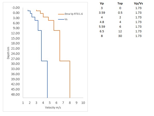
with E in erg (1 erg is equal to 1-7 J).Velocity model
One-dimensional seismic velocity model used to localize earthquakes. It is the model of Hirn et al. (1991) (see figure below). The elevation of the top surface of the layer model defined by the TEST(8) (RT8 in the figure) is set at 1.6 km.
Weight-code
According to the Hypoellipse manual, this is the relative weight assigned to each readings. It can range from 0 for the most impulsive to 4 for readings that are too uncertain to be used in the hypocentral solution. For processing the Mount Etna seismic data, 0, 1, 2, and 3 weight-codes are assigned to arrivals with reading uncertainties of up to 0.1, 0.13, 0.2, and 0.4 s, respectively.
Zone
Municipality or geographical landmark closest to the epicentre. The seismic events with a number of pickings less than 8 are indicated in orange, whereas the ones not localised are indicated in red. In this last case, just the stations detecting the seismic event are reported.